With citizen intelligence each of us can contribute from home to get on the track of grievances or crimes. After all, broad civilian attention establishes a difficult framework for breaking the law and can, under certain circumstances, prevent serious consequences.
Read more: In digital fight for justiceDuring the Citizen Science Days, the Ars Electronica Center therefore offers a series of exciting workshops that give future whistleblowers the opportunity to equip themselves with the necessary skills and tools. In this way, they not only investigate environmental crimes, but also violations of data protection or political grievances.
An incredible discovery has already been made at an first Citizen Science workshop: While looking for signs of an unfortunately quite common environmental crime, a suspicious trace on the sea surface off the Black Sea coast of Romania pointed the participants to an oil spill, which in combination with further tools could even provide first clues to the possible polluters. We spoke with Phillip Gartlehner, Infotrainer and initiator of the Toolbox for Civil Investigation workshop series, about the investigative methods, the major goals and initial successes of this initiative.
Phil, what motivates you, how did you come up with the idea for this workshop? How do you know about all these useful digital tools?

Tool kit
Use these cyber tools to track down a common environmental crime:
- EO Browser – ESA Satellite images
- vesselfinder – Shiptracking
- marinetraffic – Shiptracking
- Earth.Nullschool for measurements of wind, circulation, particles, and more
Phil Gartlehner: Although the pollution of the world’s oceans is one of the most pressing environmental problems worldwide, only a vanishingly small part of the world’s population has so far committed itself to active marine protection. Many of us feel helpless or consider our personal scope for action to be too limited. While we like to pass on the responsibility to politicians, we are usually not aware enough that we ourselves can be part of the solution. With the Citizen Science Days we want to invite people to see themselves as future creators.
We learned about the idea of using open source sources like satellite imagery or sensor data, webcams and also methods like geolocation or chronolocation from the investigative research group Bellingcat. It explains very well in its posts how it conducts the research and which sources it uses. On the one hand, it’s enormously exciting, and on the other, it’s educational. But we got the idea about the oil slicks through Skytruth. This is an NGO that deals with this topic, among other things, and now even uses its AI model ‘Cerulean’ to automatically search for oil spills.
The tools in our digital toolbox that we use in our workshops at the Citizen Science Days at the Ars Electronica Center are not new to many NGOs or journalists. We simply try out the methods and tools ourselves together with the participants – without AI, but with Citizen Intelligence.
What methods and tools do you use and what have you discovered this way?
Phil Gartlehner: In images taken on February 18, 2023 by the Sentinel-1 radar satellite from the ‘Copernicus EO browser’, we discovered a suspicious trail in the Black Sea off the coast of Romania. A smooth oil film reflects the satellite’s signals differently than a rather rough water surface, making it recognizable and detectable. Because we were already familiar with similar structures on radar images in the Global Shift exhibition at the Ars Electronica Center, we were able to assume that this track could be an oil spill.
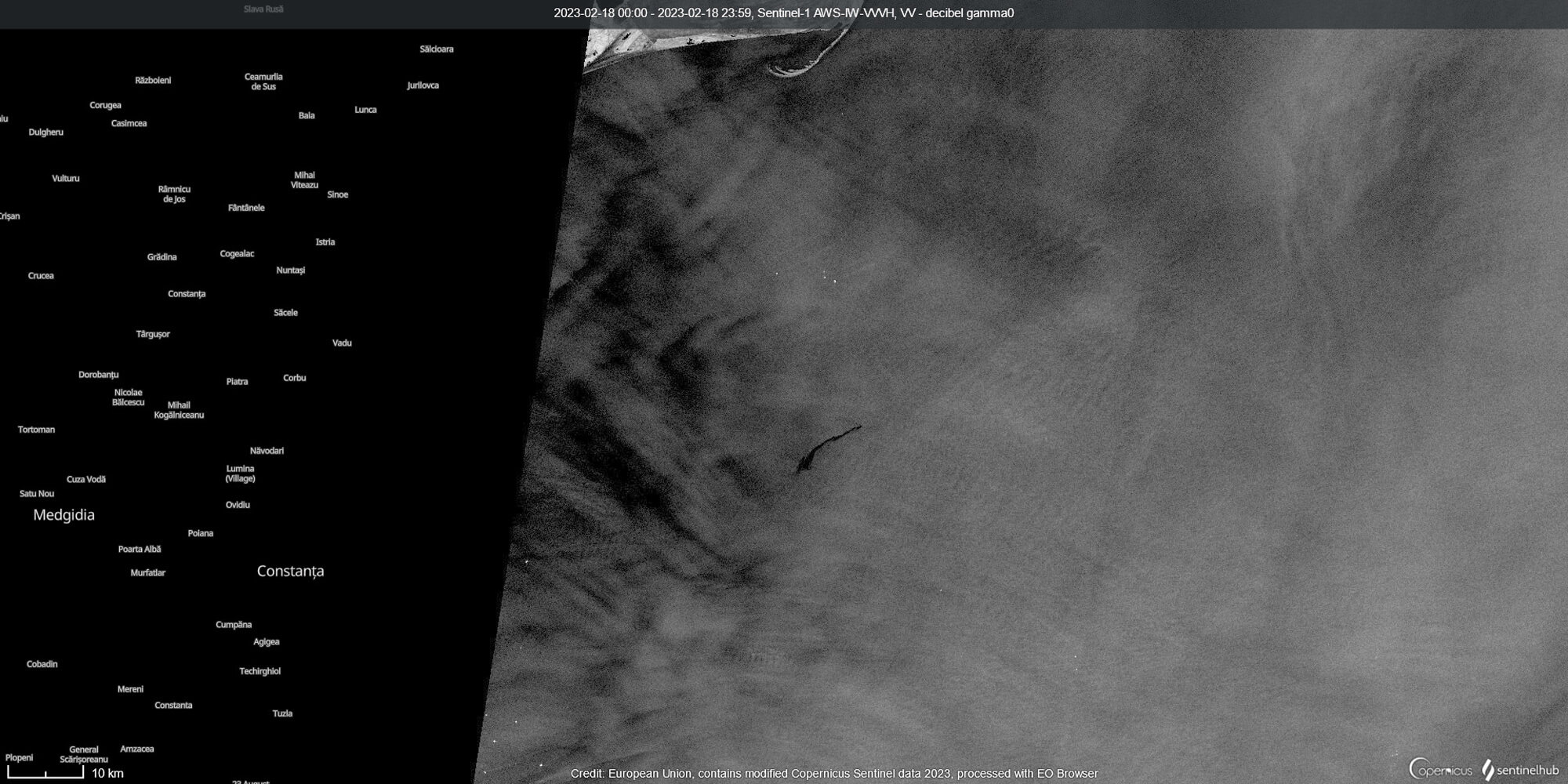
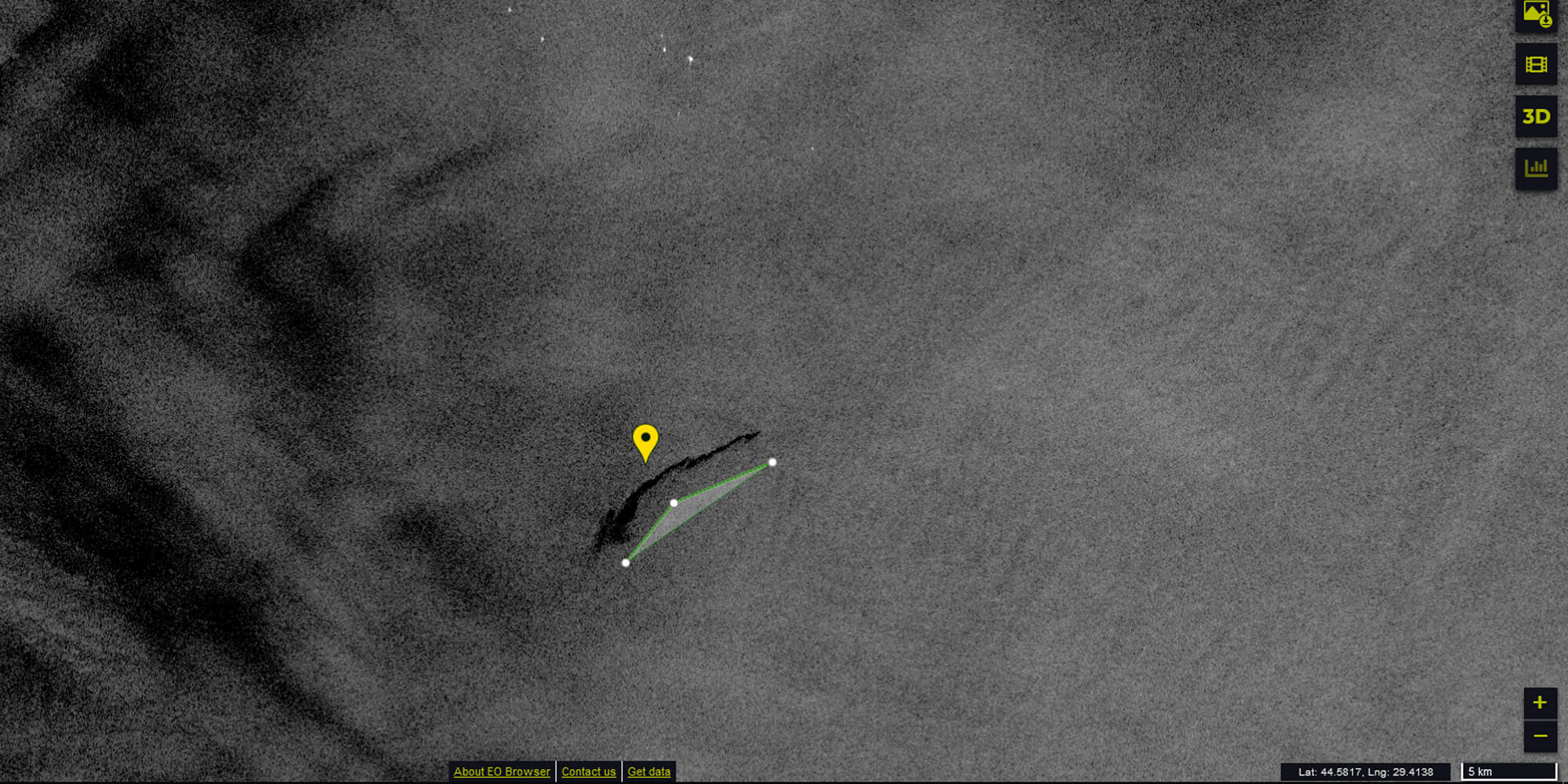
There are also oil and gas platforms in the Black Sea that could be possible sources of the pollution, but none of them are in close proximity to the suspicious track. So we focused on ships as potential polluters. To find out which one might have lost the oil, or perhaps even illegally secreted it to clean the tank, we initially only knew the “scene” and approximate “time” of the incident. Cleaning ship tanks in the open sea is unfortunately a common practice that goes unpunished far too often.
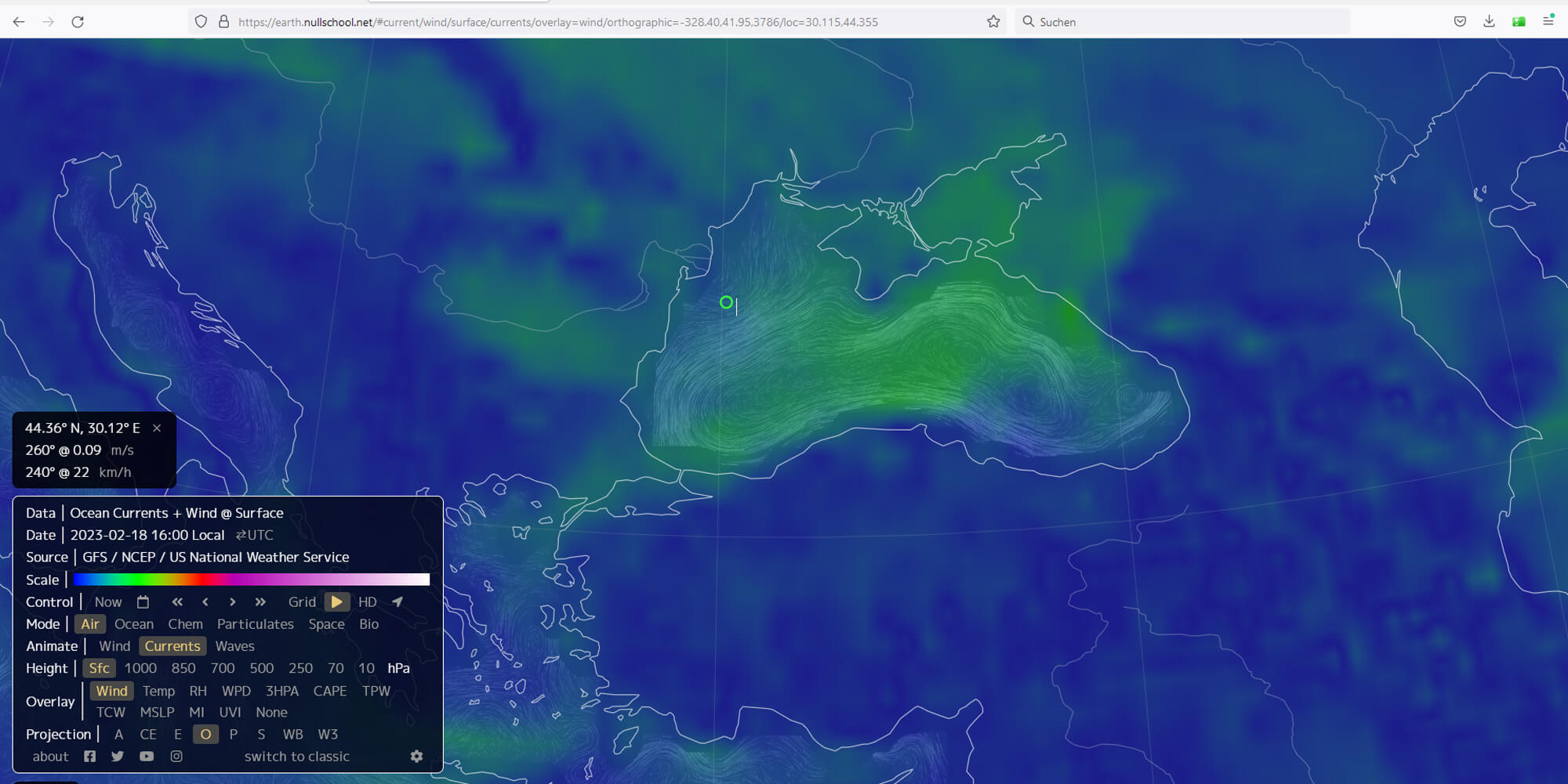
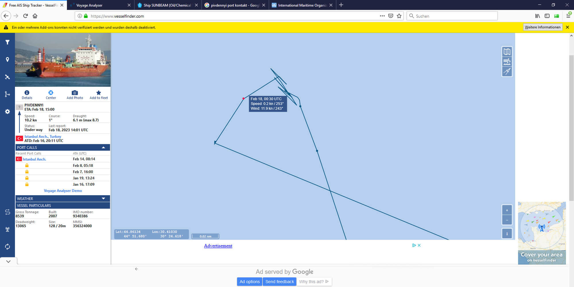
Sites such as ‘marinetraffic.com’ or “vesselfinder.com” provide live tracking of the names, owners, routes, speeds and much more information on the large transport vessels. While I checked the February 18 visualizations of ocean currents, wind and wave directions on another website, my colleague David joined the participants in taking a closer look at the ships near the coordinates.
One oil tanker seemed particularly suspicious to us: The ‘Sunbeam’ was on its way from Istanbul to Odessa, and made a stopover near the spot where we later discovered the oil. The strange maneuvers of the ‘Sunbeam’ are recorded on the map. After a few hours the ship changed the route slightly and continued.
What did you do with all this exciting information?
Phil Gartlehner: When we contacted the International Maritime Organization (IMO) and sent them our information as screenshots, we received a quick response. They thanked us and gave us the contact details of the Romanian Maritime Authority in Constanta. In such incidents, it is not enough to work only with satellite images. It must also be inspected on site to make more detailed investigations.
Now we are eagerly waiting for the result of the further investigation of this case. It was our goal to change things, to improve things, and now this incident will be followed up in any case. So, if necessary, the oil can be removed as best as possible and polluters should be held accountable. But now this has to be clarified by other institutions.
You also want to take the helm yourself and change the world for the better with the Citizen Science initiatives of Ars Electronica? Become a civil intelligence agent yourself as soon as possible! The upcoming Citizen Science Days will take place on SA 18.3. and SA 15.4. Next time we will focus on the topics “political grievances”, “extremism”, “conspiracies” and “hate in the net”. Details are still secret, but we want to reveal one thing to you now: This will be a true Citizen Intelligence fireworks show!
Professionally, Phil Gartlehner is responsible for Earth observation, citizen science and climate and energy issues in the Ars Electronica Center. In his private life, on the other hand, he’s interested in Earth observation, citizen science as well as climate and energy issues and theater. Separating his professional and private life is not his strong point, but wearing various headgear is.